User guide#
PyGeoOps provides some less common or extended spatial algorithms and utility functions.
A full list of functionalities can be found in the API reference.
As a quick start, here are some examples on how PyGeoOps can be used.
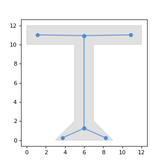
Determine the centerline() for polygons#
# For a single polygon
wkt = "POLYGON ((0 0, 0 8, -2 10, 4 10, 2 8, 2 2, 10 2, 10 0, 0 0))"
polygon = shapely.from_wkt(wkt)
centerline = pygeoops.centerline(polygon)

# For a Geopandas dataframe with polygons
gdf = gpd.GeoDataFrame(geometry=[polygon])
centerlines_gdf = gdf.copy()
centerlines_gdf.geometry = pygeoops.centerline(gdf.geometry)
(Source code, png, hires.png, pdf)

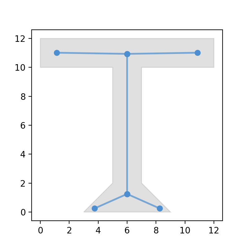
Calculate a variable width buffer with buffer_by_m()#
Calculates a buffer where the width at each vertex is determined by the Z or M dimension of the geometry. If an M dimension is present, it is used. Otherwise, the Z dimension is used.
# For a line with the Z dimension already included
line = shapely.LineString([[0, 6, 1], [0, 0, 2], [10, 0, 2], [13, 5, 4]])
buffer_geom = pygeoops.buffer_by_m(line)

# If the distances are separately available, they can be added like this
line = shapely.LineString([[0, 6], [0, 0], [10, 0], [13, 5]])
distances = [1, 2, 2, 4]
line_with_m = shapely.LineString(
    [[x, y, m] for (x, y), m in zip(line.coords, distances)]
)
buffer_geom = pygeoops.buffer_by_m(line_with_m)
(Source code, png, hires.png, pdf)
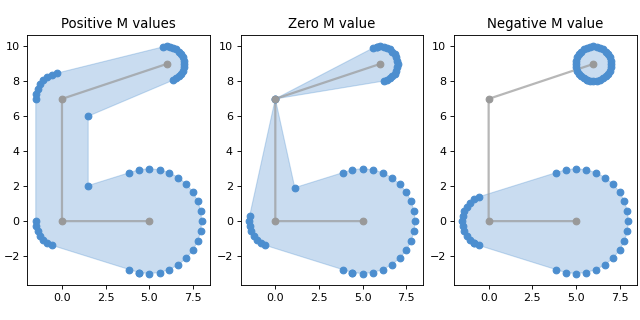
Determine view_angles() from a viewpoint towards polygons#
viewpoint = shapely.Point(10, 20)
polygons = [
    shapely.from_wkt("POLYGON((1 0, 1 1, 2 1, 2 0, 1 0))"),
    shapely.from_wkt("POLYGON((-1 0, -1 1, -2 1, -2 0, -1 0))")
]
visible_geoms_gdf = geopandas.GeoDataFrame(geometry=polygons)
)
angles_df = pandas.DataFrame(
    pygeoops.view_angles(viewpoint, visible_geoms_gdf.geometry.values),
    columns=["angle_start", "angle_end"],
    index=visible_geoms_gdf.index,
)